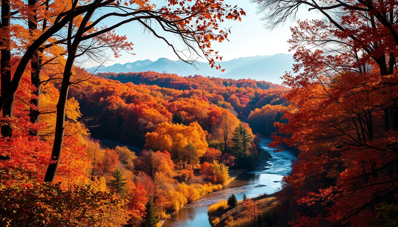
Surprising fact: each autumn the southern Appalachians can display more than a dozen shades of red, orange, and gold across a single ridge, turning a weekend into a vivid memory you won’t forget.
You’re planning a trip that pairs bright fall foliage and roaring waterfalls into one seamless escape. Cooler air and clear blue skies set the stage as mountain summits, gorges, and river valleys trade green for brilliant colors.
From easy boardwalks to short hikes and scenic train rides in north georgia, this season offers camera-ready moments at every turn. You’ll find rim overlooks, lofty peaks, and cozy mountain towns that make the journey as rewarding as the destination.
Read on to map a fall loop that links iconic parks like Tallulah Gorge, Cloudland Canyon, and Amicalola Falls while timing your visit to catch peak color and powerful waterfall flow.
Key Takeaways
- Autumn turns the southern Appalachians into a rich palette of reds and golds.
- Combine short hikes, scenic drives, and train rides for varied views.
- Plan a north georgia loop to hit top parks and hidden waterfall spots.
- Check local reports to time your visit for peak color and flow.
- Choose a relaxed pace to savor beauty and capture photos without rush.
Best time to catch peak fall colors in North Georgia
Timing matters. Aim for the last week of October through early November to catch the true peak of the season. Higher ridgelines change first, then the color moves down into valleys and toward the city.
Start in north georgia in late October and work your way south if you’re road-tripping. That approach gives you the widest window to see peak color across different elevations.
Use the Georgia State Parks Leaf Watch and national prediction maps to plan weeks ahead. Then check updates each day so you can adjust routes to where leaves are peaking now.

- Target late October–early November for the most vibrant leaves.
- Follow higher elevations first, then lower canopies as the season progresses.
- Build flexibility into your itinerary and pack layers for cool mornings and mild afternoons.
Top foliage-and-waterfall destinations to put on your list
Plan a loop that pairs dramatic rim overlooks and short hikes to find the season’s richest color and rushing cascades. Below are five must-see spots that combine accessible trails, canyon rims, and powerful water features for an unforgettable outing.

Tallulah Gorge State Park
Why go: dizzying rim overlooks and a swaying suspension bridge about 80 feet above the river. Trails of 2–4 miles lead to close-up scenes at Hurricane Falls.
Cloudland Canyon State Park
Why go: eastern and western rim routes and a Waterfalls Trail that descends into a steep-walled canyon. Early peak color often brightens this northwestern location.
Amicalola Falls State Park
Why go: Georgia’s tallest cascade, boardwalk viewpoints, and stair climbs that connect to the AT Approach Trail for added hiking options.
Anna Ruby Falls (near Helen)
Why go: an easy 0.9-mile round-trip paved trail to twin cascades. This location delivers big color and sound with minimal miles and effort.
Beech Bottom Trail to Jacks River Falls (Cohutta Wilderness)
Why go: a roughly 9-mile round-trip backcountry hike to remote pools that mirror peak color. Expect quieter spots and classic wilderness valleys.
| Destination | Key features | Trail length | Ideal stop type |
|---|---|---|---|
| Tallulah Gorge State Park | Rim overlooks, suspension bridge, Hurricane Falls | 2–4 miles | Short hike / dramatic gorge |
| Cloudland Canyon State Park | East/West rim trails, Waterfalls Trail, steep canyon | Varies (short to moderate) | Rim walks / canyon descent |
| Amicalola Falls State Park | Tallest cascade, boardwalks, AT approach | Short to long options | Quick viewpoint / extended hike |
| Anna Ruby Falls | Twin cascades, paved path | 0.9 miles | Easy, family-friendly |
| Beech Bottom Trail to Jacks River Falls | Remote pools, backcountry solitude | ~9 miles round-trip | Full-day wilderness hike |
- Mix rim overlooks and short trails for varied scenery.
- Include Fort Mountain State park as a quiet add-on to broaden your route.
- Pack layers and plan for changing light to capture top colors near canyon rims and bridges.
Panoramic views to pair with your waterfall days
Plan a high-stop between canyon treks and stair climbs to see how the season spreads across ridges. A summit morning or late-afternoon overlook gives context to the close-up scenes you find near streams.
Brasstown Bald rises to 4,784 feet and offers a 360-degree observation deck. You can hike a short, steep trail or take the shuttle. On clear days, multiple states appear on the horizon and the layered colors ripple across mountains and valleys.
Black Rock Mountain State Park is Georgia’s highest-elevation state park. The 2.2-mile Tennessee Rock Trail leads to a lofty overlook. Early-season color often arrives here first, so roadside overlooks and the summit visitor center are great low-effort stops that still deliver sweeping views.

- You’ll stand atop Brasstown Bald at 4,784 feet to take in 360-degree views where colors ripple across ridges.
- You’ll choose the short summit hike or ride the shuttle, then wander the observation deck as valleys glow in fall light.
- You’ll hike Tennessee Rock for high-elevation panoramas that show how the north georgia mountains change.
| Location | Feature | Why stop |
|---|---|---|
| Brasstown Bald | 4,784 feet, observation deck, shuttle | Full 360-degree panoramas; multi-state horizon |
| Black Rock Mountain State Park | Tennessee Rock Trail (2.2 mi), visitor center | Early color, high-elevation overlooks, easy roadside stops |
| Roadside overlooks | Multiple pull-offs along ridges | Fast payoff when you want views without long hikes |
Scenic routes and rides that amplify the season’s beauty
A scenic drive or a relaxed rail ride can turn a crisp autumn day into a memory of layered color and rushing streams. These routes let you move slowly through mountains and valleys while stopping at overlooks and picnic spots.
Russell Scenic Byway: Chattahoochee National Forest’s rolling color and mountain water
The Russell Scenic Byway runs about 40.6 miles through the Chattahoochee National Forest. You’ll find abundant pull-offs for quick photos, short walks, and glimpses of mountain water where creeks cross the road.
You’ll use the byway to link canyon rim stops and quiet park trailheads. It’s an easy way to see fall foliage without a long hike.
Blue Ridge Scenic Railway: riverside foliage from an open-air car
The Blue Ridge Scenic Railway operates seasonally from roughly late September to early November. You can choose a two-hour or four-hour trip along the Toccoa River.
Open-air cars float you past riverside color, and a border-town layover in McCaysville, GA, and Copperhill, TN gives time to explore local shops and photo spots.

- You’ll cruise the byway for rolling forest scenes and water glimpses close to the road.
- You’ll board the train to relax while riverside colors pass by in open-air comfort.
- You’ll tailor your trip by choosing a shorter ride for town time or a longer run with a layover.
| Route | Length / Time | Highlights |
|---|---|---|
| Russell Scenic Byway | 40.6 miles | Pull-offs, forested ridges, creek and river glimpses |
| Blue Ridge Scenic Railway | 2 or 4 hours | Open-air cars, Toccoa River, McCaysville/Copperhill layover |
| Combined day | Flexible | Link drives, short hikes, and a park stop for diverse spots |
Link a byway drive to a short trail or station stop, and you’ll create one of the hidden cabins or town moments that make a trip feel complete.
Trail-tested tips for an unforgettable, safe autumn hike
When the air bites and colors deepen, a careful hike gives you safe, memorable moments on the ridge. Use simple planning to keep your outing joyful and low-stress.

Layer up, plan for hunting season, and pack the essentials
Dress in layers so you can shed or add clothing as temperatures shift. Start cool, warm up on the way, then bundle at overlooks when breezes pick up.
Plan around hunting dates for the area and wear high-visibility clothing. Consider blaze orange and stay on marked trails to reduce risk.
“Pack for the unexpected: water, map or GPS, snacks, headlamp, and a small first-aid kit.”
- You’ll keep a route card or phone route saved if cell service drops.
- You’ll start early, park legally, and have a backup way if your chosen trail is full.
- You’ll practice Leave No Trace to protect the forest under the leaf carpet.
| Concern | Practical step | Why it matters |
|---|---|---|
| Variable temps | Layer clothing | Stay comfortable and avoid hypothermia or overheating |
| Hunting season | Wear high-visibility; check dates | Reduce risk and stay visible on multi-use trails |
| Slippery terrain | Watch for wet leaves and use trekking poles | Prevent falls near streams and cascades |
Match your route to your group’s comfort. Choose short trails on windy days and longer ridge hikes on calm, blue-sky afternoons. That way you leave with only good memories of this season in the mountains.
Georgias best Fall Foliage Views With Waterfalls
Plan a compact loop that pairs canyon rims, thunderous cascades, and sweeping mountain overlooks across north Georgia.
Build a North Georgia loop: Tallulah Gorge, Cloudland Canyon, and Amicalola Falls
Start at Tallulah Gorge State Park for rim overlooks and the suspension bridge, then drive toward Cloudland Canyon State Park to follow rim trails and the Waterfalls Trail.
Finish your trip at Amicalola Falls State Park to take in boardwalk and staircase views of the cascade. Expect about 2–6 miles of hiking per day so you can savor each stop.
- You’ll string together these parks as a one- to two-day circuit that balances short hikes and scenic drives.
- You’ll plan 1–3 hour driving segments between trailheads and pick lodging mid-route to reduce backtracking.
- You’ll add Fort Mountain State for a bonus stop—tower overlooks and ancient stone features that broaden your color perspectives.
Timing matters: move northwest first to catch earlier peak color, then slide southeast as the season deepens. That way you craft your own best places see the palette and the views you want to linger on.
Conclusion
Set a gentle pace to move from high summits down to river valleys and catch peak color at every elevation. Plan short hikes, train rides, and scenic drives so each stop feels effortless and full of beauty.
, Use timing and elevation to chase fall foliage across north georgia. Visit a state park rim, stand on a summit deck, then follow a gorge trail to hear water and see leaf color up close.
You’ll leave with photos and quiet memories—colors framed by mountains, forest light, and small moments between trailheads. Keep safety simple: layers, bright clothes during hunting season, and trail essentials so every day ends well.
FAQ
When is the ideal window to see peak leaf color in north Georgia?
Peak color typically happens from late October through early November. Elevation affects timing, so higher spots like Brasstown Bald will turn sooner than lower valleys. Check local leaf reports before you go.
How can I track color changes across Georgia state parks?
Use the Georgia State Parks Leaf Watch and park social media for weekly updates. Call park visitor centers like Tallulah Gorge or Cloudland Canyon for current conditions and trail advisories.
Which parks offer both dramatic falls and accessible overlooks?
Tallulah Gorge State Park has rim overlooks and a suspension bridge with views toward Hurricane Falls. Amicalola Falls State Park features Georgia’s tallest single-drop falls with nearby viewing platforms. Anna Ruby Falls is an easy walk to twin cascades framed by hardwoods.
Where can I find remote waterfall hikes with fewer crowds?
The Beech Bottom Trail to Jacks River Falls in the Cohutta Wilderness offers a backcountry experience with pools that mirror autumn color. Expect rougher terrain and limited services—plan accordingly.
What panoramic summits pair well with waterfall visits?
Brasstown Bald provides a 360-degree view at 4,784 feet, ideal after a waterfall morning. Black Rock Mountain State Park’s Tennessee Rock overlook delivers high-elevation color that complements nearby cascades.
Which scenic drives help you see both foliage and mountain water?
The Russell Scenic Byway threads through the Chattahoochee National Forest with rolling color and streamside vistas. For a relaxed ride, the Blue Ridge Scenic Railway offers riverside foliage viewing from vintage cars.
What should I pack for autumn hikes near waterfalls?
Layered clothing, waterproof footwear, a map or GPS, water, snacks, and a first-aid kit. Bring traction if trails are wet and warn that hunting season means bright clothing and awareness of posted regulations.
How can I build a practical loop to see Tallulah Gorge, Cloudland Canyon, and Amicalola Falls?
Plan a multi-day loop starting at one park, then drive between sites—Tallulah Gorge to Amicalola is a manageable day’s route, with Cloudland Canyon best paired on the return through northwest Georgia. Book lodging in Dahlonega or Blue Ridge and allow time for trails and overlooks.
Are there accessibility options for people with limited mobility?
Many parks provide accessible parking and paved overlooks. Anna Ruby Falls and parts of Amicalola have shorter, easier paths and viewing areas. Contact individual park offices for current accessibility details and available facilities.
How crowded do these destinations get on peak weekends, and how can I avoid the rush?
Weekends during late October and early November are busiest. Visit midweek, arrive early, or explore less-known trails like Beech Bottom for quieter experiences. Parking fills fast at popular overlooks—plan extra time.